Agents and brokerages
Your client asks whether it is leasehold, whether it has a cesspool, and whether the last owner pulled permits. Answer all three before the showing, and send them the map link.
Search ≈326,000 Oʻahu properties and ≈172,000 mapped parcels. Land tenure, assessed value, flood zone, sea-level rise, cesspool evidence, short-term-rental registration, zoning and permits — each with its source and the date it was published.
Search ≈326,000 Oʻahu properties and ≈172,000 mapped parcels — tenure, assessed value, flood, sea-level rise, cesspool, short-term rental, zoning and permits, each with its source and date.
Free. No account required.
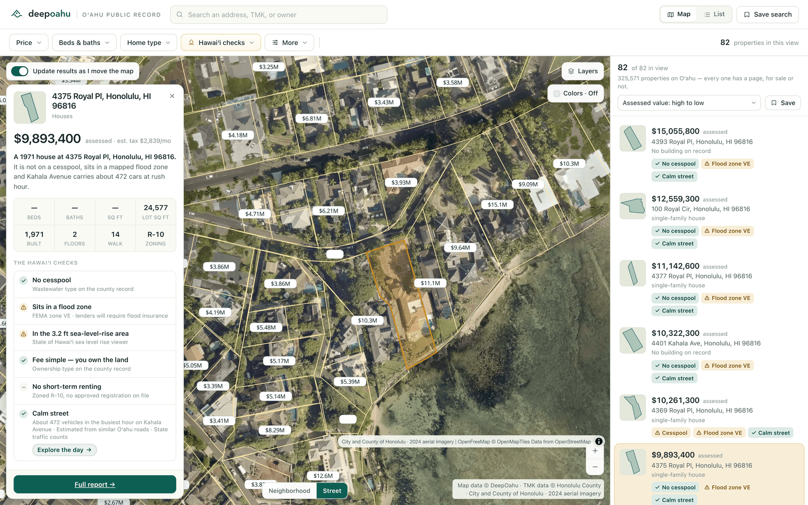
Type an address. Each of these is answered from the record and from the property itself, with the source and the date it was published shown beside it.
Fee simple or leasehold, from the county's ownership-type record.
The official zone, and whether it is a Special Flood Hazard Area.
Against the State's 3.2 ft inundation modelling.
Mapped cesspool evidence and the Department of Health replacement-priority band.
From the county's short-term-rental registry.
Permit history, 2005–2025, and the building record.
Zoning class with its description, and the county assessment split into land and building, with exemptions.
Owner of record and tax-bill mailing address — the owner-occupant versus absentee signal.
The parcel boundary drawn over the City and County of Honolulu 2024 aerial capture, at 7.94 cm per pixel at the deepest level.
Driveways, structures, pools, hedge lines and lānai, read against the mapped boundary of the parcel they sit on.
Physical change detection across the aerial record, alongside the permit and property timeline for the parcel.
True view measurement from a chosen point on the property, naming the structure or terrain that closes the rest of the sector.
Future-view obstruction risk, recomputed against a modelled neighbouring buildout under the zoning envelope.
Observed hourly vehicle volume from the nearest counter station or modelled road profile, with the distance to it stated.
Every view has a URL, so you can send someone the exact map you are looking at.
Colour the whole island by assessed value, flood zone, sea-level rise, cesspool, zoning, walkability or short-term-rental registration — one at a time, because two colourings on the same parcel are two claims and you can only check one.
Filter by what actually decides it: price, size, year built, zoning, walkability, owner-occupancy, and the five Hawaiʻi checks — each of which works in both directions, so you can look for parcels without a cesspool, or specifically for the ones that have one.
Explore the map
Three jobs the record does every day.
Your client asks whether it is leasehold, whether it has a cesspool, and whether the last owner pulled permits. Answer all three before the showing, and send them the map link.
Screen the island by zoning, lot size, assessed value and owner-occupancy, then check flood, sea-level rise and permit history on the parcels that survive — before anyone spends a week on a site visit.
Check short-term-rental registration, permit history and hazard context across a portfolio without opening five county websites for every address.
Public records describe a property on paper. They do not tell you what can be seen from it, how steep it is, what could be built next door, or what has physically changed since last year. Deep Oʻahu measures those things from geospatial evidence and publishes each one as what it is — a measurement, with the evidence it was drawn from beside it.
Every measurement carries its evidence class and its source, exactly as a public-record field does.
See the intelligence layer →Three claims, each of which you can check against the county's own record.
Leasehold, cesspool replacement priority, short-term-rental registration and sea-level-rise exposure are not fields a national product carries, because they matter in very few places. They matter here.
A condo tower is one parcel and hundreds of separately owned properties. We keep those distinct: every CPR unit gets its own page with its own assessment and owner, sharing the parcel it actually sits on. Getting this wrong is why other tools show you a tower and call it a house.
There is no proprietary rating here. Every value is a public-record field or a calculation we will show you, with the source and the date beside it, and a link to the county’s own record.

Every property page, every map layer and every Hawaiʻi check is free and always will be. That is not a trial, and there is no account to create.
$0
No account, no trial period, no card.
The whole map and every property page. Never paywalled.
$99/month
Founding price, locked for 12 months. $990 a year, or $149 a month at list.
For people who research Oʻahu property for a living.
From $600/month
Five seats. $1,100 for ten, $2,400 for twenty-five, quoted above that.
Brokerages, developer teams and analyst groups.
From $199
One property, one document, delivered in two business days.
Every public record that bears on one property, with a source on every line.
API & data access·Talk to us
Four classes of evidence, kept separate on every page, so you always know which kind of claim you are reading.
Fields published by an identified public authority — the county assessment roll, the State's parcel and zoning layers, FEMA's flood mapping, the Department of Health's cesspool inventory, the county permit record. We keep every field a source publishes, and we keep its date.
Reproducible geometry: does this parcel intersect the sea-level-rise area, how far is it from the nearest traffic counter, which properties sit on this parcel. The same inputs give the same answer, every time.
Model inferences, such as classifying what is visible in imagery. Each carries a confidence value and the evidence it was drawn from, and each is labelled an observation rather than a fact.
Which class of evidence produced this number, which source it came from, and when that source last published. If you disagree with a field, the county's own record is one click away.
Deep Oʻahu is a research tool. It is not a survey, an appraisal, a title report, an engineering report, a legal opinion, or an insurance determination. Verify anything material with the authoritative source or a licensed professional.
Open the map and look up a property you already know. If what you find is not more than you could get anywhere else, we have not done our job.